Case Study - Skyline
How Pardee Homes balanced a 27MM yd3 jobsite
to just 20K yd3 using JETIAir
Project Background
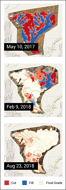 When Pardee Homes (Tri Pointe Homes subsidiary), an award-winning residential home building company in Southern California, opened its Skyline Ranch grading project to bids, most contractors believed the project was beyond their capacity to handle. For the hilly 500-acre site, the developer wanted 27MM yd3 of total cut moved in just 17 months. Some approvals were still pending and model homes were designed to be in the middle of the site, so the job had to be built out of sequence at the risk of serious dirt imbalance.
Independent Construction Company (ICC), one of the largest grading contractors in California, decided to take the risky job. The ICC team went to Pardee Homes and proposed using TraceAir’s Balance Solution powered by drones. Pardee Homes saw the opportunity to address project challenges with the technology and saw it as one more benefit of giving the job to ICC.
Even though some team members were skeptical about the technology’s accuracy and its ability to contribute to balancing the project from the start, Pardee Homes managed to finish grading ahead of time by one month with only 20k yd3 of a long haul. This is less than 0.1% of the total cut – accuracy that is unheard of in the industry. Read on to find out how the team did it.
Downloads
- LANDFILLS
- WETLANDS MITIGATION
- LAND DEVELOPMENT
- RESIDENTIAL PADS & ROADS
- PIPELINES
- HIGHWAYS
- COMMERCIAL BUILDERS
- ADDITIONAL CASE STUDY DOWNLOADS
When Drones Can Be Used Instead of Hand or Aerial Topographic Maps
Creating topographic map (topo) by hand for a project this complex would have been costly and impractical. A crew of two people would need to shoot points for four days minimum, at a cost of at least $6,400 ($100 per hour per crew member), and another day to create a surface from shots.
 It would take about a week for the project team to receive a surface of the topography lacking in visual information. By the time the surface is created and delivered, the topography on the project would have changed, rendering the surface outdated. Many details would be missing, as grade checkers wouldn’t be able to cover every spot on the site. Over the course of the project, the team might receive three topographic surfaces at best.
Similarly, an aerial topo from a plane would be expensive costing around $15K per flight. Also, it would take at least two weeks for scheduling the flyover, conducting the flight and processing the data. The contour map produced would have up to 0.5 ft point deviation that will produce significant inaccuracies when calculating volumes.
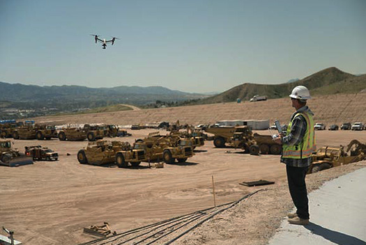
Mapping the site with drones took just a few hours, it was safe and cost approximately $1,500. At the start of the project, an ICC grade setter spent a single day setting flight markers across the site so the drone topo could be georeferenced to coordinates on the ground. Outside of active construction zones, flight markers required minimal maintenance.
Instead of creating a topo of the site using a GPS rover, which would have required the grade setter to walk on steep slopes and shoot points by hand, the grade setter flew a drone to collect hundreds of photos that would be uploaded to the TraceAir platform to create a digital copy of the site. A single drone flyover took a few hours to complete, allowing the team to see a near real-time 3D map in under 24 hours, twice a week.
The accuracy of the topography put the project team’s initial concerns to rest. Occasionally, as the project progressed, the construction team shot random points on the site and compared them with the elevations provided by TraceAir to ensure consistent accuracy. They found TraceAir elevations to be, on average, within 1/10 of a foot of the GPS rover’s measurements.
Reducing the Gap Between the Field and the Office
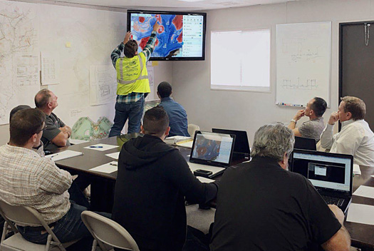 Without readily available data, project teams debate site issues for hours. Typical grading meetings scheduled for one hour last two hours or more — meaning an extra hour of work for all 10 meeting participants including owners, contractors, civil engineers, geotechnical engineers, and consultants in attendance at an additional cost of a couple thousand dollars per week.
After the grading meeting, questions are often left unanswered and require additional work or followups. Thus decisions would have to be postponed until the next weekly meeting when the necessary information finally becomes available.
With an up-to-date “living” map of the site projected on a screen in the meeting room, the entire team had a clear, accurate view of the most recent site condition. In addition to a visual representation of the site, the team had quantifiable data related to overall site balance, slopes, cut/fill in specific areas, and the amount of dirt moved daily. Having these precise measurements at hand unified the team and helped the owners make decisions on the spot.
A short time after adopting TraceAir technology, the construction team stopped questioning one another and started working together more effectively. Time spent in grading meetings was reduced by half, to well under one hour.
Using New Information to Balance the Project
The project team had some understanding of how the dirt is going to behave during grading based on soil tests collected by geotechnical engineers at the beginning of the project. However, there were not enough tests to estimate a representative bulk/shrink coefficient for the site. Additional testing was expensive and impractical. However, a slight error in bulk/shrink coefficient estimate could lead to shortage/excess of hundreds of thousands of yd3 of dirt, which cost millions of dollars to deal with due to the large area of the site.
As the project progressed, TraceAir provided the team with near real-time cut/fill maps of the project every week which showed dirt balance of the whole site, as well as of specific areas. A few months into the project, TraceAir was used by the team to calculate an average for the bulk/shrink coefficient of excavated dirt using historical data from previous flyovers. The calculated coefficient was used to forecast how the remaining dirt would behave in the future. Using this information, the construction team was able to see early that with the current final grade design, the project will end up long by 600k yd3.
The team decided to reduce the excess of dirt by revising the grading design. The TraceAir platform was projected on a large screen during meetings and used to discuss potential changes with Civil Engineers right at the meeting. TraceAir helped the team communicate their thoughts in a clear visual way and helped avoid misunderstandings regarding the new design proposed by the civil engineers. With accurate, detailed existing grade information from TraceAir, Civil Engineers were able to accommodate the excess of dirt in the most efficient way.
"A very powerful tool..."
"When you’re moving half a million yards a week, and you’re working in five or six locations at one time, there’s a lot of changing going on. TraceAir gave us real-time information about how much material we moved.
This is a very powerful, forward-looking tool; I don’t know how we got along without it before."
– Bob Ogier, Project Superintendent,
Independent Construction Company
Having the Right Tools Transformed the Process
With almost real-time information about the current site grade and bulk/shrink estimates, the team was able to finish grading with just 20k yd3 of long haul to balance. This is less than 0.1% of the total contract volume – unheard-of accuracy in the industry. Apart from helping to balance the site, TraceAir provided the grading contractor with unique tools to move dirt faster, eliminate long hauls, double handling, and rework. That helped the team to finish the project ahead of schedule and reduce costs.
We Appreciate All Our Clients...
 "In the beginning with such a complex project, our goal was to finish on time and on budget. Halfway through the grading operations, we became confident that with TraceAir, our team would meet and exceed these goals. We completed the grading ahead of schedule and under budget. "
